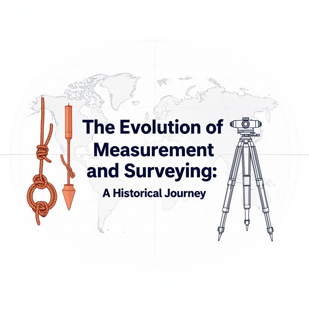
The Evolution of Measurement and Surveying: A Historical Journey
Source Information: This study material is compiled from a lecture audio transcript ("Podit Podcast") and copy-pasted text, integrating information from both sources to provide a comprehensive overview.
1. Introduction: Why Measurement Matters 🌍
Measurement and surveying have been fundamental to human progress, enabling civilizations to build, organize, and expand. The ability to accurately measure distance, direction, level, and position with repeatable tools was not just a convenience but a prerequisite for advancement.
✅ Key Impact Areas:
- Engineering: Construction of canals, roads, and cities.
- Mapping: Creation of detailed maps for various purposes.
- Administration & Logistics: Facilitating taxation, managing road networks, and organizing armies.
📈 Evolutionary Arc: Surveying evolved from basic field measurements using simple tools to sophisticated national surveys, continuously enhancing precision and scope.
2. Ancient Foundations: Early Field Craft and Precision 🛠️
2.1. Ancient Egypt: The Rope-Stretchers 🇪🇬
Early systematic measurement began in ancient Egypt, driven by the need to re-establish land boundaries after the annual Nile floods.
📚 Key Practitioners:
- Harpedonaptai (Rope-stretchers): Specialists who reset field boundaries.
✅ Tools & Techniques:
- Knotted Ropes: Used for measuring distances and creating right angles (e.g., the 12-knot rope forming a "3-4-5" right triangle).
- Cubit Rods: Standardized units of length.
- Plumb Bobs & Water Levels: Used to establish horizontal planes.
2.2. Ancient Greece: The Dioptra 🇬🇷
Hellenistic engineers introduced greater precision, particularly in angle measurement.
📚 Key Instrument:
- Dioptra: A sophisticated sighting rule mounted on a calibrated stand.
✅ Applications:
- Refined angle sighting for aqueduct alignments.
- Precise astronomical observations.
- Considered a direct forerunner of the modern theodolite.
- Hero of Alexandria's treatise describes its precise use and adjusting screws.
2.3. Ancient Rome: Engineering on the March 🏛️
Roman surveyors advanced techniques for large-scale infrastructure projects.
📚 Key Instruments:
- Groma: Used for establishing perfectly straight alignments, crucial for their extensive road networks.
- Chorobates: A beam equipped with plumb lines or a water trough, used for leveling aqueducts.
- Odometer: An early device described for automatically logging distances, vital for mapping roads and planning itineraries.
3. Mapping the World: Grids, Geodesy, and Navigation 🗺️
3.1. Ptolemy's Geography: The Mathematical Framework 🌐
Claudius Ptolemy's work provided a foundational structure for cartography.
✅ Key Contributions:
- Latitude-Longitude Grids: Codified mapping using these coordinate systems.
- Map-Projection Methods: Offered various techniques for representing the spherical Earth on a flat surface.
- Provided a durable mathematical framework that was later revived and expanded.
3.2. The Islamic Golden Age: Instruments and Geodesy 🌟
This era saw significant advancements in instrumentation and the science of Earth measurement.
📚 Key Instruments:
- Astrolabe & Specialized Quadrants: Widely used and refined, with designs and tables spreading through translations.
💡 Notable Achievements:
- Al-Biruni: Measured Earth's radius using a mountain-top angle-of-dip method, an early and elegant example of geodesy.
- Ibn al-Haytham: His work on optics (including the camera obscura) refined sighting techniques and instrument theory.
3.3. Navigation Boosts Surveying: Compass and Portolan Charts 🧭
Innovations in maritime navigation significantly influenced land surveying.
📚 Key Innovations:
- Magnetic Compass: Developed in China and adopted in medieval Europe, enabling heading-based surveys at sea.
- Portolan Charts (13th Century Mediterranean): Practical and highly accurate sea charts characterized by dense rhumb-line networks derived from compass bearings. These profoundly influenced land mapping techniques.
4. Renaissance Innovations: Precision and Systematization 📐
4.1. Renaissance Field Methods: Plane Table and Theodolite ✍️
The Renaissance brought new tools that enhanced efficiency and accuracy in the field.
📚 Key Instruments:
- Plane Table: Allowed surveyors to draw features directly in the field along sight lines, significantly speeding up topographic mapping.
- Theodolite: The term appeared with Leonard and Thomas Digges (1571), marking the maturation of angle-measuring instruments towards modern forms.
4.2. Triangulation as a System: Regional Mapping 📏
A monumental conceptual leap that transformed local measurements into comprehensive regional maps.
📚 Key Figures & Concepts:
- Gemma Frisius (1533): Outlined the principle of triangulation – fixing a baseline, measuring angles, and computing the rest.
- Willebrord Snellius (1615): Executed instrumental triangulation on a meridian arc in the Netherlands, setting a new standard for national surveys.
4.3. Scaling Up Accuracy: Chains, Telescopes, and Verniers 🎯
Further innovations dramatically improved the precision and consistency of measurements.
📚 Key Innovations:
- Gunter's Chain (1620): Standardized land measurement (66 feet, 100 links), making area and distance calculations fast and consistent.
- Telescopic Sights: Improved the accuracy of sighting.
- Vernier Scales (Pierre Vernier, 1631): Enhanced angle reading precision to minutes of arc, boosting overall survey accuracy to unprecedented levels.
Conclusion: A Cornerstone of Human Endeavor ✅
From the simple ropes of ancient Egypt to the sophisticated instruments of the Renaissance, the continuous evolution of measurement and surveying techniques has been a cornerstone of human development. These advancements have not only enabled the construction of magnificent structures and the mapping of our world but have also underpinned the administrative and logistical frameworks of societies throughout history.