Turkey's Climate: Understanding Temperature - kapak
Eğitim#turkey climate#temperature#geography#climate factors

Turkey's Climate: Understanding Temperature

Explore the key factors influencing temperature across Turkey, from latitude and altitude to maritime and continental effects. Learn how these elements shape the diverse climate regions.

3iswv0pjJune 12, 2026 ~12 dk toplam
01

Görsel Özet

İnfografik

Konunun tüm parçalarını tek bakışta gör.

Turkey's Climate: Understanding Temperature - görsel özet infografik
Tam boyutta görüntüle →
02

Flash Kartlar

25 kart

Karta tıklayarak çevir. ← → ile gez, ⎵ ile çevir.

1 / 25
Tüm kartları metin olarak gör
  1. 1. What is the primary focus of this content regarding Turkey's climate?

    The primary focus of this content is Turkey's Climate Information, specifically concentrating on Temperature. It aims to explain why Turkey exhibits such a wide range of temperatures despite its size and to break down the factors influencing its thermal landscape.

  2. 2. Why is temperature considered a fundamental element in shaping Turkey's climate?

    Temperature is fundamental because it dictates the distinct climatic zones across Turkey, ranging from mild, humid coasts to harsh, snowy interiors. Its variations are crucial in defining the overall climate patterns and influencing various aspects like agriculture and lifestyle throughout the country.

  3. 3. What is the first key factor influencing temperature distribution in Turkey?

    The first key factor influencing temperature distribution in Turkey is latitude. Turkey is located in the Northern Hemisphere, between approximately 36 and 42 degrees North latitude. This geographical position means that the angle of the sun's rays changes significantly from south to north, directly impacting average temperatures.

  4. 4. How does Turkey's latitude affect its temperature patterns?

    Turkey's latitude, ranging from 36 to 42 degrees North, means that as one moves from the southern parts towards the north, the angle at which the sun's rays strike the Earth's surface becomes less direct. This decrease in the sun's angle generally leads to lower average temperatures in the northern regions compared to the southern ones.

  5. 5. Provide an example of how latitude influences temperature differences within Turkey.

    An excellent example of latitude's influence is the contrast between the Mediterranean coast and the Black Sea region. The Mediterranean coast, being at a lower latitude, generally experiences warmer temperatures due to more direct sun exposure. In contrast, the Black Sea region, located further north, tends to be cooler on average.

  6. 6. What is the approximate latitudinal range of Turkey?

    Turkey is located in the Northern Hemisphere, approximately between 36 and 42 degrees North latitude. This specific latitudinal range is a primary determinant of the varying solar radiation received across different parts of the country, contributing to its diverse temperature profiles.

  7. 7. Explain the general relationship between latitude and temperature in Turkey.

    In Turkey, there is a general inverse relationship between latitude and temperature. As you move from the lower latitudes in the south (like the Mediterranean coast) to the higher latitudes in the north (like the Black Sea region), the average temperatures tend to decrease. This is primarily due to the diminishing angle of the sun's rays at higher latitudes.

  8. 8. What is the second crucial factor influencing temperature in Turkey, besides latitude?

    The second crucial factor influencing temperature in Turkey is altitude. Turkey has a significantly mountainous terrain, particularly in regions like Eastern Anatolia. Higher altitudes lead to a noticeable drop in temperature, making it a critical determinant of local climate conditions.

  9. 9. How much does temperature typically drop for every 200 meters of ascent in Turkey?

    For every 200 meters one ascends in altitude, the temperature typically drops by about 1 degree Celsius. This consistent rate of temperature decrease with increasing elevation is a fundamental principle that explains why mountainous regions in Turkey are significantly colder than lower-lying areas.

  10. 10. In which region of Turkey is the effect of altitude on temperature most pronounced?

    The effect of altitude on temperature is most pronounced in Eastern Anatolia. This region is characterized by its high mountainous terrain, which results in significantly colder conditions and much longer, harsher winters compared to other parts of Turkey.

  11. 11. Describe the impact of high altitudes on winter conditions in Turkey.

    High altitudes in Turkey, especially in regions like Eastern Anatolia, lead to significantly colder conditions and much longer winters. The substantial drop in temperature with increasing elevation means that these areas experience severe cold and heavy snowfall for extended periods, making winters particularly harsh.

  12. 12. Why do mountainous regions in Turkey experience colder temperatures?

    Mountainous regions in Turkey experience colder temperatures primarily due to the effect of altitude. As elevation increases, the air becomes thinner and less able to retain heat, leading to a temperature drop of approximately 1 degree Celsius for every 200 meters ascended. This results in significantly colder conditions compared to lower-lying areas.

  13. 13. What is the 'maritime effect' and how does it influence Turkey's temperature?

    The 'maritime effect,' or proximity to the sea, refers to the moderating influence large bodies of water have on coastal temperatures. In Turkey, coastal areas like the Aegean and Mediterranean regions experience milder winters and cooler summers because water heats up and cools down slower than land, thus stabilizing temperature fluctuations.

  14. 14. Which regions in Turkey primarily benefit from the maritime effect?

    The regions in Turkey that primarily benefit from the maritime effect are the coastal areas, specifically the Aegean and Mediterranean regions. These areas experience the moderating influence of the sea, leading to more temperate conditions throughout the year compared to inland areas.

  15. 15. How do coastal areas in Turkey differ from inland areas in terms of winter temperatures?

    Coastal areas in Turkey, due to the maritime effect, experience milder winters compared to inland areas. The sea's ability to retain heat longer than land prevents extreme cold, resulting in more moderate winter temperatures along the Aegean and Mediterranean coasts.

  16. 16. How do coastal areas in Turkey differ from inland areas in terms of summer temperatures?

    Coastal areas in Turkey, influenced by the maritime effect, experience cooler summers compared to inland areas. The sea's moderating influence prevents temperatures from rising to the extreme highs seen in continental interiors, leading to more comfortable summer conditions along the coasts.

  17. 17. Why does water moderate temperature fluctuations more effectively than land?

    Water moderates temperature fluctuations more effectively than land because it has a higher specific heat capacity, meaning it requires more energy to change its temperature. Consequently, large bodies of water heat up and cool down slower than land, leading to more stable and moderate temperatures in adjacent coastal areas.

  18. 18. Define the 'continental effect' in the context of Turkey's climate.

    The 'continental effect' describes the climatic characteristics of inland areas that are far from the moderating influence of the sea. In Turkey, these regions exhibit much hotter summers and much colder winters, resulting in a significantly larger annual temperature range compared to coastal areas.

  19. 19. Which regions in Turkey are prime examples of the continental effect?

    Central and Eastern Anatolia are prime examples of regions in Turkey that exhibit a strong continental effect. These inland areas are far from the sea's moderating influence, leading to extreme temperature variations with very hot summers and very cold winters.

  20. 20. How do inland areas in Turkey differ from coastal areas in terms of annual temperature range?

    Inland areas in Turkey, characterized by the continental effect, exhibit a much larger annual temperature range compared to coastal areas. This means they experience significantly hotter summers and much colder winters, whereas coastal regions have more moderate temperature fluctuations throughout the year.

  21. 21. What are the typical summer and winter conditions in regions experiencing a strong continental effect in Turkey?

    Regions experiencing a strong continental effect in Turkey, such as Central and Eastern Anatolia, typically have much hotter and often dry summers. In contrast, their winters are much colder, often accompanied by significant snowfall, leading to a wide annual temperature variation.

  22. 22. How do relief and mountain ranges influence temperature distribution in Turkey?

    Relief and mountain ranges act as significant barriers that influence temperature distribution in Turkey. They block the moderating effects of the seas from reaching inland areas, create distinct microclimates, and can lead to rain shadows, profoundly shaping regional temperature patterns.

  23. 23. Give an example of how mountain ranges act as barriers to maritime influence in Turkey.

    The North Anatolian Mountains serve as a prime example, preventing the moderating effects of the Black Sea from reaching inland areas. Similarly, the Taurus Mountains block Mediterranean influences from penetrating into Central Anatolia, leading to more extreme temperatures in the interior.

  24. 24. What is a 'rain shadow' and how can mountain ranges create it in Turkey?

    A 'rain shadow' is a dry area on the leeward side of a mountainous region. Mountain ranges in Turkey, such as the Taurus or North Anatolian Mountains, force moist air to rise and release precipitation on their windward side. By the time the air descends on the leeward side, it is dry, creating a rain shadow effect and influencing local temperatures.

  25. 25. How do mountain ranges contribute to the creation of distinct microclimates in Turkey?

    Mountain ranges contribute to distinct microclimates in Turkey by creating variations in exposure to sun, wind, and precipitation over short distances. Their barrier effect, differences in altitude, and the creation of rain shadows lead to localized climatic conditions that can differ significantly from the broader regional climate.

03

Detaylı Özet

7 dk okuma

Tüm konuyu derinlemesine, başlık başlık.

This content is based on a YouTube video.


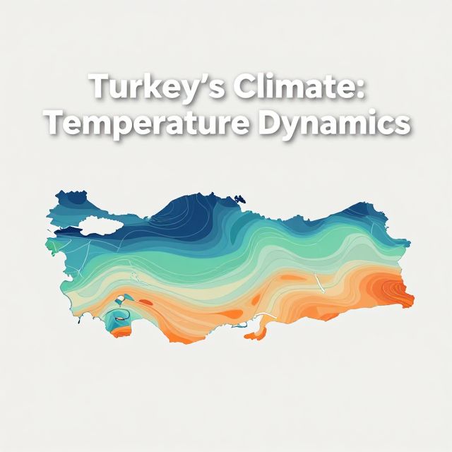
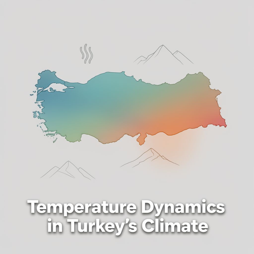
🇹🇷 Turkey's Climate Information: Temperature Dynamics

📚 Introduction to Turkey's Temperature Landscape

Welcome to this comprehensive study guide on the temperature dynamics of Turkey! Despite its relatively modest size, Turkey exhibits a remarkably diverse range of temperatures, from the mild, humid conditions along its coasts to the harsh, snowy extremes of its interior regions. This variation is not random but is shaped by a fundamental interplay of geographical factors. Understanding these elements is crucial for grasping the 'why' behind Turkey's varied thermal landscape and its impact on everything from agriculture to daily life.

This guide will break down the primary factors that influence temperature distribution across Turkey, providing a clear and structured overview to aid your understanding and retention.


🌡️ Key Factors Influencing Temperature in Turkey

Several fundamental geographical factors interact to determine the temperature patterns observed throughout Turkey. Each factor contributes uniquely to the thermal characteristics of different regions.
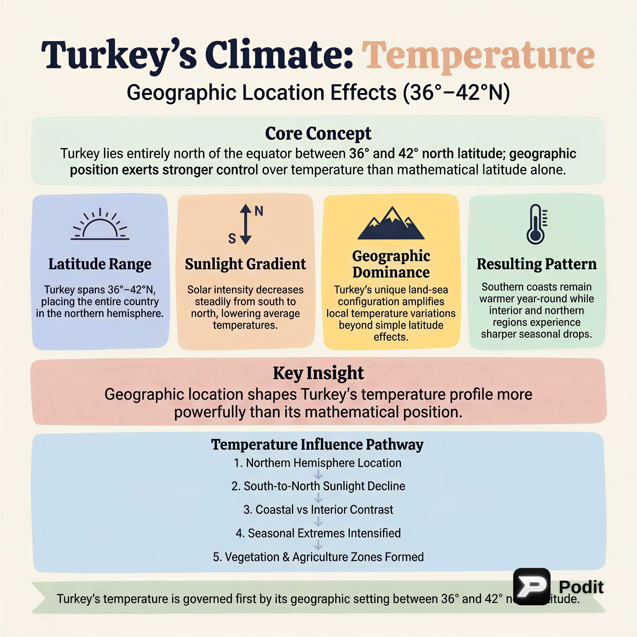
1️⃣ Latitude

📚 Definition: Latitude refers to the angular distance of a place north or south of the Earth's equator, usually expressed in degrees and minutes. It is a primary determinant of the angle at which the sun's rays strike the Earth's surface.

Impact in Turkey:

  • Turkey is situated in the Northern Hemisphere, spanning approximately 36 to 42 degrees North latitude.
  • As one moves from the south to the north across Turkey, the angle of the sun's rays becomes progressively less direct (more oblique).
  • This decreasing angle of incidence generally leads to lower average temperatures in northern regions compared to southern regions.
  • 💡 Example: The warmer Mediterranean coast in the south experiences higher average temperatures due to more direct sunlight compared to the cooler Black Sea region in the north.

2️⃣ Altitude (Elevation)

📚 Definition: Altitude is the height of an object or point in relation to sea level or ground level. In meteorology, it significantly affects temperature due to the decreasing density of the atmosphere with increasing height.

Impact in Turkey:

  • Temperature generally decreases with increasing altitude.
  • The standard atmospheric lapse rate indicates that for every 200 meters (approximately 656 feet) one ascends, the temperature typically drops by about 1 degree Celsius (1.8 degrees Fahrenheit).
  • Turkey's terrain is notably mountainous, particularly in regions like Eastern Anatolia.
  • High altitudes in these areas result in significantly colder conditions, shorter growing seasons, and longer, more severe winters.
  • 💡 Real-world observation: The noticeable drop in temperature when driving up a mountain pass is a direct manifestation of the altitude effect.

3️⃣ Proximity to the Sea (Maritime Effect)

📚 Definition: The maritime effect describes the moderating influence that large bodies of water, such as oceans and seas, have on the temperature of nearby landmasses. Water heats up and cools down much slower than land.

Impact in Turkey:

  • Coastal areas of Turkey, including the Aegean and Mediterranean regions, experience a pronounced maritime effect.
  • This leads to milder winters and cooler summers compared to inland areas at similar latitudes.
  • The sea acts as a thermal regulator, absorbing heat slowly in summer and releasing it slowly in winter, thus reducing temperature fluctuations.
  • The high specific heat capacity of water is the underlying reason for this moderating influence.

4️⃣ Continental Effect

📚 Definition: The continental effect (or continentality) refers to the tendency of landmasses to experience greater extremes of temperature (hotter summers, colder winters) compared to coastal areas, due to land's lower specific heat capacity and lack of moderating influence from large water bodies.

Impact in Turkey:

  • Inland areas of Turkey, far removed from the moderating influence of the seas, exhibit a strong continental effect.
  • These regions experience much hotter summers and much colder winters, resulting in a significantly larger annual temperature range.
  • ⚠️ Key Contrast: This is the opposite of the maritime effect.
  • 💡 Examples: Central Anatolia and Eastern Anatolia are prime examples of regions dominated by a continental climate, characterized by stark seasonal temperature differences.

5️⃣ Relief and Mountain Ranges

📚 Definition: Relief refers to the variations in elevation and slope of the Earth's surface. Mountain ranges, as significant relief features, play a critical role in shaping regional climates by acting as physical barriers.

Impact in Turkey:

  • Turkey's prominent mountain ranges significantly influence temperature distribution by blocking air masses and modifying climatic influences.
  • North Anatolian Mountains: These ranges run parallel to the Black Sea coast. They prevent the moderating, humid effects of the Black Sea from penetrating far inland, contributing to the continental climate of Central Anatolia.
  • Taurus Mountains: Located in the south, these mountains similarly block the maritime influences of the Mediterranean Sea from reaching Central Anatolia.
  • Microclimates and Rain Shadows: Mountain ranges can also create localized microclimates. For instance, they often lead to rain shadow effects on their leeward sides, where precipitation is significantly reduced, which can indirectly affect temperature by influencing humidity and cloud cover.
  • The orientation and height of these mountains are crucial in determining which regions receive maritime influence and which remain continental.

📈 Temperature Distribution and Seasonal Variations in Turkey

The interaction of the factors discussed above creates distinct temperature patterns and seasonal variations across Turkey.

Regional Temperature Patterns

  • Mediterranean and Aegean Coasts (South and West):

    • Warmest regions, especially in summer.
    • Influenced by lower latitude (more direct sunlight) and strong maritime effect.
    • Characterized by hot, dry summers and mild, rainy winters.
    • 💡 Example: Cities like Antalya and Izmir exemplify these conditions.
  • Eastern Anatolia (East):

    • Coldest regions, particularly in winter.
    • Dominated by high altitude and a very strong continental effect.
    • Experiences very harsh, long, and snowy winters with significant temperature drops. Summers can be warm but short.
    • 💡 Example: Kars and Erzurum are known for their extremely cold winters.
  • Central Anatolia (Central):

    • ✅ Experiences a typical continental climate.
    • Characterized by hot, dry summers and cold, snowy winters.
    • The mountain ranges (North Anatolian and Taurus) block maritime influences, enhancing continentality.
    • 💡 Example: Ankara, the capital, showcases these distinct seasonal temperature differences.
  • Black Sea Coast (North):

    • ✅ Experiences a maritime climate, but with unique characteristics.
    • Influenced by its higher latitude compared to the Mediterranean coast, leading to generally cooler temperatures.
    • The North Anatolian Mountains trap moisture, resulting in milder but often humid and rainy conditions throughout the year, including summer.
    • Winters are mild but can be rainy.
    • 💡 Example: Trabzon and Rize are known for their lush, humid climate.

Seasonal Variations

Turkey experiences pronounced seasonal variations, which are critical for understanding its climate.

  • Summers (June, July, August):

    • Generally hot and dry across most of the country.
    • The Mediterranean and Aegean coasts are particularly hot and sunny, ideal for tourism.
    • Central and Eastern Anatolia also experience hot summers, but with lower humidity and significant diurnal (day-night) temperature ranges due to continentality.
    • ⚠️ Exception: The Black Sea coast is an exception, receiving rainfall even during summer, making it humid and less intensely hot than other coastal areas.
  • Winters (December, January, February):

    • Vary significantly depending on the region.
    • Coasts (Mediterranean, Aegean, Black Sea): Generally mild and rainy. Snowfall is rare or light, especially on the Mediterranean and Aegean coasts.
    • Eastern and Central Anatolia: Experience severely cold and snowy winters. Temperatures can drop well below freezing, and snow cover can last for months, particularly in Eastern Anatolia due to high altitude and continentality.
    • 💡 Impact: These variations directly influence agricultural practices, types of crops grown, and even the architectural styles and daily lifestyles of people in different regions.

💡 Conclusion: A Tapestry of Temperatures

In summary, Turkey's temperature landscape is a rich and complex tapestry, intricately woven by the interplay of several key geographical factors. These include:

  • Latitude: Determining the angle of solar radiation.
  • Altitude: Causing temperature to decrease with height.
  • Proximity to the Sea (Maritime Effect): Moderating coastal temperatures.
  • Continental Effect: Leading to extreme seasonal temperatures inland.
  • Relief and Mountain Ranges: Acting as barriers and creating distinct climatic zones.

These elements do not act in isolation but interact dynamically to create a diverse range of thermal conditions, from the temperate and humid coasts to the extreme and arid interiors. By grasping these fundamental concepts, you have taken a significant step in understanding the intricate and fascinating climate of Turkey.

Keep exploring and observing the world around you; you will undoubtedly see these geographical principles in action every day, shaping environments and human activities alike. Great job on learning about this crucial aspect of Turkey's geography!

Kendi çalışma materyalini oluştur

PDF, YouTube videosu veya herhangi bir konuyu dakikalar içinde podcast, özet, flash kart ve quiz'e dönüştür. 1.000.000+ kullanıcı tercih ediyor.

Sıradaki Konular

Tümünü keşfet
Geographical Location: Absolute vs. Relative

Geographical Location: Absolute vs. Relative

Explore the fundamental concepts of geographical location, differentiating between absolute (mathematical) and relative (special) location, and their significance in geography.

25 15 Görsel
Geographical Location: Absolute and Relative Aspects

Geographical Location: Absolute and Relative Aspects

An academic overview of absolute and relative geographical location, focusing on key concepts and their application to Turkey's geography, relevant for the KPSS examination.

8 dk Özet 25 15
Turkey's Climate: Temperature Dynamics

Turkey's Climate: Temperature Dynamics

An academic overview of temperature characteristics and influencing factors across Turkey, essential for understanding its diverse climate zones and for educational contexts like the KPSS examinations.

5 dk Özet 25 15
Temperature Dynamics in Turkey's Climate

Temperature Dynamics in Turkey's Climate

An academic overview of temperature distribution and its influencing factors across Turkey, covering geographical principles relevant to climate studies and educational curricula.

5 dk Özet 25 15
Introduction to Geography for KPSS-MEB AGS 2026

Introduction to Geography for KPSS-MEB AGS 2026

This audio summary provides an academic overview of foundational geographical concepts relevant to the KPSS-MEB Field Knowledge Examination, specifically focusing on introductory geography principles.

5 dk Özet 25 15 Görsel
Introduction to Geography for KPSS-AGS Examination

Introduction to Geography for KPSS-AGS Examination

This summary provides an academic overview of foundational geographical concepts relevant to the KPSS-AGS examination for prospective geography teachers in Turkey, emphasizing key principles and their educational significance.

6 dk Özet 25 15
Geographical Location of Turkey: Absolute and Relative Aspects

Geographical Location of Turkey: Absolute and Relative Aspects

This summary explores Turkey's geographical location, differentiating between absolute and relative positions. It covers parallels, meridians, and the geopolitical significance of its unique placement.

7 dk 25
Turkey's Landforms: Internal and External Geologic Forces

Turkey's Landforms: Internal and External Geologic Forces

This summary explores the geological processes shaping Turkey's diverse landforms, focusing on the interplay of internal (tectonic) and external (erosional/depositional) forces. Key geomorphological concepts are discussed.

5 dk Özet 25 15 Görsel